Who made the first map?
Imagine how hard is to explain to someone the exact location of all the streets and buildings in your city.
It would be easier to draw a picture or diagram layout in such a case, and the result would be – a map!
According to historical data, the first map ever made was made from clay and then baked, more than 4,000 years ago in Egypt.Then the landlords usually used maps to mark the boundaries of their property, and the kings used the maps to mark the boundaries of their kingdoms.
But when people tried to show the positions of some remote places on the map, they run into some obstacles.
Here is why.
The Earth has a round shape, so it was difficult to accurately measure long distances. Astronomers have been of great help to the first drawers of maps because they were engaged in their studies and about the size and shape of the Earth.
A Greek man named Eratosthenes born 276 BC, calculated the size of the Earth's volume and came very close to the exact figures.
His methods were first allowed to accurately calculate the distance to the north-south.
Around this time, Hipparchus proposed that the map of the world would be evenly divided by imaginary lines of latitude (parallels) and longitude.
Around this time, Hipparchus proposed that the map of the world would be evenly divided by imaginary lines of latitude (parallels) and longitude.
The exact location of these lines, Hipparchus, must be based on the knowledge gained by studying the sky.
Ptolemy in the second century, used the same idea and draw a better map, with evenly spaced parallels. His book on geography was world recognized text until the discovery of America .
Discoveries of Christopher Colombo and many others have greatly increased interest in maps.
This map is known as “projection", where the surface of the Earth is " projected" or transferred to the surface of the maps.
On the front page of Mercator's book was a drawing of the Giant Atlas, therefore today the collection of maps is called "Atlas".
Ptolemy in the second century, used the same idea and draw a better map, with evenly spaced parallels. His book on geography was world recognized text until the discovery of America .
Discoveries of Christopher Colombo and many others have greatly increased interest in maps.
The first large collection of maps was published by Abraham Ortelius from Antwerp in 1570.
Gerardus Mercator became the father of modern cartography.
 |
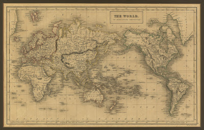
| The World on Mercator's Projection - from the General Atlas of the World published by A & C Black in 1840 |
He drew a map where all curved lines on the globe, became straight lines on the map. In this way the map could show a straight line between two points that corresponded with the direction obtained by using a compass.


Social Plugin